Kujawsko-Pomorska Digital Library contains 259 678 digital objects
Object
Available formats:
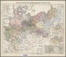
Download allTitle: Darstellung der territorialen Entwicklung des Brandenburgisch-Preussischen Staates vom Jahre 1415 bis jetzt
Description:
Skala nieoznaczona ; 1 mapa : kolorowa ; 38 x 46 cm, złożona 22x13 cm. ; Tytuł z panela ; Mapy poboczne: Besitzungen des gr. Kurfürsten in Africa; Kriegsschauplätze in Frankreich, Belgien den Niederlanden; Deutschland u. d. angränzenden Länder i. J. 1807; Schlacht bei Leipzig 16-19. October 1813; Schlacht bei Königgrätz 3. July 1866 ; Na górnej ramce długość geograficzna według Paryża, na dolnej według Ferro
Contributor:
Brecher, Adolf (1836-1901) ; Dietrich Reimer Verlag
Publisher:
Verlag von Dietrich Reimer ; Lith. Anst. v. Leopold Krantz
Place of publication:
Format:
Original identifier:
Language:
Relation:
Digital object identifier:
Rights:
Domena publiczna (Public domain)
Access Rights:
Resource Identifier:
Digitalisation:
Biblioteka Uniwersytecka w Toruniu
Original in:
Biblioteka Uniwersytecka w Toruniu
Sponsor:
Program Operacyjny Polska Cyfrowa POPC.02.03.01-00-0039/18
Object collections:
Last modified:
Nov 15, 2023
In our library since:
Sep 8, 2020
Number of object content hits:
44
Number of object content views in Galeria format
22
Number of object content views in PDF format
50
All available object's versions:
https://kpbc.umk.pl/publication/205948
Show description in RDF format:
Show description in OAI-PMH format:
| Edition name | Date |
|---|---|
| Darstellung der territorialen Entwicklung des Brandenburgisch-Preussischen Staates vom Jahre 1415 bis jetzt | Nov 15, 2023 |
Contact details
Visit us!