Kujawsko-Pomorska Digital Library contains 263 521 digital objects
Object
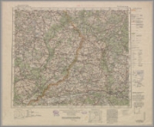
Title: Bromberg P 54 ; P 54 Bromberg
Description:
Skala 1:300 000 ; 1 mapa : kolor. ;39x46 cm, na ark. 48x58 cm ; Tyt. z mapy ; Rzeźba terenu przedstawiona metodą kreskową i punktami wysokościowymi.
Contributor:
Prusy. Landesaufnahme ; Niemcy. Reichsamt für Landesaufnahme
Publisher:
Place of publication:
Format:
Original identifier:
Language:
Relation:
Übersichtskarte von Mitteleuropa
Digital object identifier:
Rights:
Domena publiczna (Public domain)
Access Rights:
Resource Identifier:
Digitalisation:
Biblioteka Uniwersytecka w Toruniu
Original in:
Biblioteka Uniwersytecka w Toruniu
Sponsor:
Ministerstwo Nauki i Szkolnictwa Wyższego, grant nr 884/P-DUN/2013/2014
Object collections:
- Kujawsko-Pomorska Digital Library > Cultural heritage > Maps
- Kujawsko-Pomorska Digital Library > Regional materials > Cuiaviana, Pomeranica > Maps
Last modified:
Nov 15, 2023
In our library since:
Aug 7, 2014
Number of object content hits:
134
Number of object content views in DjVu format
133
All available object's versions:
https://kpbc.umk.pl/publication/78647
Show description in RDF format:
Show description in OAI-PMH format:
| Edition name | Date |
|---|---|
| Bromberg P 54 | Nov 15, 2023 |
Objects Similar
Prusy. Königliche Preussische Landesaufnahme Kartographische Abteilung Prusy. Landesaufnahme


