Kujawsko-Pomorska Digital Library contains 258 578 digital objects
Object
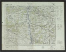
Title: Grossblatt nr 375 Opatow ; Opatow ; Opatów
Description:
1 mapa : kolor. ; 58x73 cm, 70x90 cm. ; Massstab 1:100 000. ; Przedruk niemiecki na jednym arkuszu czterech polskich map Wojskowego Instytutu Geograficznego (Solec, Opole, Opatów, Kraśnik). ; Rzeźba terenu przedst. za pomocą poziomic i punktów wysokości. ; Nad górna ramką po lewej stronie: Deutsches Reich (Gen. Gouv.) 1:100 000. ; Na marginesie objaśnienie znaków topograficznych. ; Herausg. 1944. ; Tytuł i opis mapy w języku niemieckim, nazwy geograficzne w języku polskim.
Contributor:
Niemcy. Heer Oberkommando ; Niemcy. Heer Generalstab Chef des Kriegskarten- und Vermessungswesens
Publisher:
Chef des Kriegskarten- und Vermessungsewesens
Place of publication:
Format:
Source:
Language:
Rights:
Domena publiczna (Public domain)
Access Rights:
Resource Identifier:
Digitalisation:
Wojewódzka i Miejska Biblioteka Publiczna w Bydgoszczy
Original in:
Wojewódzka i Miejska Biblioteka Publiczna w Bydgoszczy
Sponsor:
Projekt e-Kultura WZP.273.55.2014
Object collections:
- Kujawsko-Pomorska Digital Library > Cultural heritage > Maps
- Kujawsko-Pomorska Digital Library > Recommended
- Kujawsko-Pomorska Digital Library > Collections of project partners > Voivodeship and Municipal Public Library of Dr. Witold Bełza in Bydgoszcz
Last modified:
Feb 8, 2017
In our library since:
Feb 8, 2017
Number of object content hits:
61
Number of object content views in DjVu format
59
All available object's versions:
https://kpbc.umk.pl/publication/175805
Show description in RDF format:
Show description in OAI-PMH format:
| Edition name | Date |
|---|---|
| Grossblatt nr 375 Opatow | Feb 8, 2017 |
Objects Similar
Górski, Wacław (1935- )
Górski, Wacław (1935- )
Contact details
Visit us!